
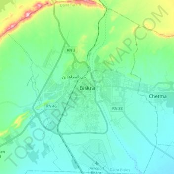
Biskra topographic map
Interactive map
Click on the map to display elevation.
About this map
Name: Biskra topographic map, elevation, terrain.
Location: Biskra, Biskra District, Biskra, Algeria (34.78560 5.65367 34.91767 5.79383)
Average elevation: 128 m
Minimum elevation: 60 m
Maximum elevation: 420 m
Apart from the mountains that surround it, the topography of Biskra is generally very flat. Part of the city is surrounded by the Sfa Pass and the Ziban Mountains. In the outskirts of Biskra, the landscape is very arid with all the same vegetation that vary depending on the location. Small water points can be found in the outskirts of Biskra, especially in the oases and canyons of the mountains around El Kantara. The prefecture of Biskra is crossed by Oued Labiod waterways, Oued El Arab, Djedi, Oued Meziraâ, Oued El and Oued el Gantara. The city covers an area of 127.55 km2 (49.25 sq mi). It has a population of 307,987 and is the 10th most populous city. It has a population density of 1,612.0 inhabitants per square meter. The population of Biskra are called Biskri.
Other topographic maps
Click on a map to view its topography, its elevation and its terrain.