
Cobija topographic map
Interactive map
Click on the map to display elevation.
About this map
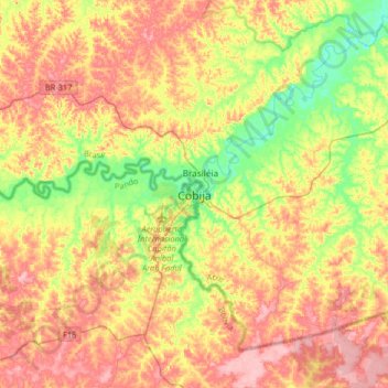
Name: Cobija topographic map, elevation, terrain.
Location: Cobija, Provincia de Nicolás Suárez, Pando, Bolivia (-11.17830 -68.91375 -10.85830 -68.59375)
Average elevation: 236 m
Minimum elevation: 172 m
Maximum elevation: 297 m
The Bolivian city of Cobija is located about 600 km (373 mi.) north of La Paz in the Amazon Basin on the border with Brazil. Cobija lies on the banks of the Rio Acre across from the Brazilian city of Brasiléia. Cobija lies at an elevation of ca. 280 m (920 ft.) above sea level and has a tropical and rainy climate.