
Surin Province topographic map
Interactive map
Click on the map to display elevation.
About this map
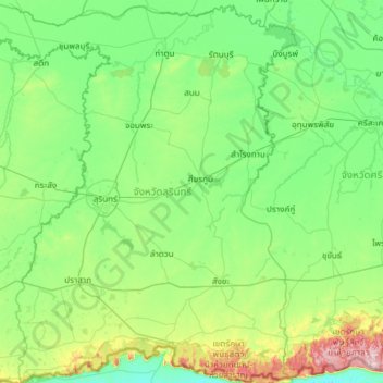
Name: Surin Province topographic map, elevation, terrain.
Location: Surin Province, Thailand (14.32757 103.08960 15.48285 104.08852)
Average elevation: 162 m
Minimum elevation: 65 m
Maximum elevation: 659 m
Surin lies at the center of the southern edge of the Khorat Plateau, a relatively low-lying interior region isolated from the rest of Southeast Asia by surrounding mountain ranges. The south of the province is dominated by the Dongrek mountain range, the escarpment of which demarcates the watershed boundaries and also forms the international border with Cambodia. The mountains, averaging approximately 500m in elevation, are not particularly high but the southward sides are steep cliffs rising rather abruptly from the northern plains of Cambodia significantly hindering any attempt at passing. The main pass in the region is in Surin and cuts through the mountains between Chong Chom and O Smach, Cambodia.
Other topographic maps
Click on a map to view its topography, its elevation and its terrain.