
Aigle topographic map
Interactive map
Click on the map to display elevation.
About this map
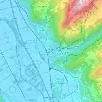
Name: Aigle topographic map, elevation, terrain.
Location: Aigle, District d'Aigle, Vaud, 1860, Switzerland (46.29131 6.93177 46.34167 7.04028)
Average elevation: 647 m
Minimum elevation: 371 m
Maximum elevation: 1,948 m
Aigle lies at an elevation of 415 m (1,362 ft) about 13 km (8.1 mi) south-southeast of Montreux. It is on the east edge of the Rhône valley, at the foot of the Swiss Alps.
Other topographic maps
Click on a map to view its topography, its elevation and its terrain.
Drapel
Switzerland > Vaud > District d'Aigle > Aigle
Drapel, Aigle, District d'Aigle, Vaud, 1860, Switzerland
Average elevation: 716 m
Vallée du Rhône
Switzerland > Vaud > District d'Aigle
Vallée du Rhône, District d'Aigle, Vaud, Switzerland
Average elevation: 1,378 m
Gryon
Switzerland > Vaud > District d'Aigle
Gryon, District d'Aigle, Vaud, 1882, Switzerland
Average elevation: 1,240 m
Leysin
Switzerland > Vaud > District d'Aigle
Leysin, District d'Aigle, Vaud, 1854, Switzerland
Average elevation: 1,352 m
Noville
Switzerland > Vaud > District d'Aigle
Noville, District d'Aigle, Vaud, 1845, Switzerland
Average elevation: 384 m
Glacier du Dar
Switzerland > Vaud > District d'Aigle > Ormont-Dessus
Glacier du Dar, Ormont-Dessus, District d'Aigle, Vaud, Switzerland
Average elevation: 2,554 m
Chambon
Switzerland > Vaud > District d'Aigle > Roche (VD)
Chambon, Roche (VD), District d'Aigle, Vaud, 1852, Switzerland
Average elevation: 485 m