
Millington topographic map
Interactive map
Click on the map to display elevation.
About this map
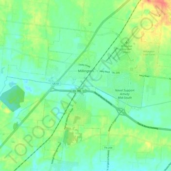
Name: Millington topographic map, elevation, terrain.
Average elevation: 87 m
Minimum elevation: 71 m
Maximum elevation: 120 m
Other topographic maps
Click on a map to view its topography, its elevation and its terrain.
Nonconnah Creek
United States > Tennessee > Shelby County > Memphis
Nonconnah Creek, Memphis, Shelby County, West Tennessee, Tennessee, United States
Average elevation: 96 m
Foote Homes
United States > Tennessee > Shelby County > Memphis
Foote Homes, Memphis, Shelby County, West Tennessee, Tennessee, 38126, United States
Average elevation: 84 m
Arlington
United States > Tennessee > Shelby County
Arlington, Shelby County, West Tennessee, Tennessee, 38802, United States
Average elevation: 97 m
Memphis
United States > Tennessee > Shelby County
Memphis, Shelby County, West Tennessee, Tennessee, United States
Average elevation: 86 m
Lake Windermere
United States > Tennessee > Shelby County > Memphis
Lake Windermere, Memphis, Shelby County, West Tennessee, Tennessee, United States
Average elevation: 93 m
Memphis
United States > Tennessee > Shelby County > Memphis
Memphis, Shelby County, West Tennessee, Tennessee, 38112, United States
Average elevation: 85 m