
Denton topographic map
Interactive map
Click on the map to display elevation.
About this map
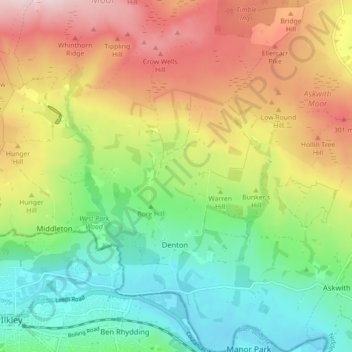
Name: Denton topographic map, elevation, terrain.
Average elevation: 189 m
Minimum elevation: 62 m
Maximum elevation: 364 m
Other topographic maps
Click on a map to view its topography, its elevation and its terrain.
Galphay
United Kingdom > England > North Yorkshire > Harrogate > Galphay
Galphay, Azerley, Harrogate, North Yorkshire, Yorkshire and the Humber, England, HG4 3NJ, United Kingdom
Average elevation: 120 m
Fewston
United Kingdom > England > North Yorkshire > Harrogate > Fewston
Fewston, Harrogate, North Yorkshire, Yorkshire and the Humber, England, United Kingdom
Average elevation: 205 m
Beckwithshaw
United Kingdom > England > North Yorkshire > Harrogate > Beckwithshaw
Beckwithshaw, Harrogate, North Yorkshire, Yorkshire and the Humber, England, HG3 1QW, United Kingdom
Average elevation: 161 m
Bilton-in-Ainsty with Bickerton
United Kingdom > England > North Yorkshire > Harrogate > Bickerton
Bilton-in-Ainsty with Bickerton, Bickerton, Harrogate, North Yorkshire, Yorkshire and the Humber, England, United Kingdom
Average elevation: 28 m