
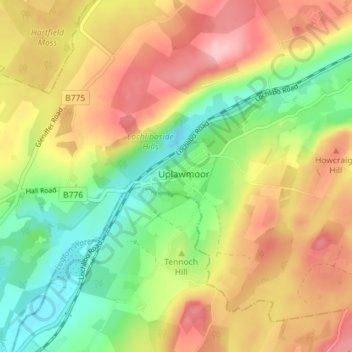
Uplawmoor topographic map
Interactive map
Click on the map to display elevation.
About this map
Name: Uplawmoor topographic map, elevation, terrain.
Average elevation: 181 m
Minimum elevation: 107 m
Maximum elevation: 256 m
Other topographic maps
Click on a map to view its topography, its elevation and its terrain.
Eaglesham
United Kingdom > Scotland > East Renfrewshire
Eaglesham, East Renfrewshire, Scotland, G76 0LG, United Kingdom
Average elevation: 172 m
Busby
United Kingdom > Scotland > East Renfrewshire
Busby, East Renfrewshire, Scotland, G76 8JZ, United Kingdom
Average elevation: 104 m
Newton Mearns
United Kingdom > Scotland > East Renfrewshire
Newton Mearns, East Renfrewshire, Scotland, G77 6EY, United Kingdom
Average elevation: 127 m
Clarkston
United Kingdom > Scotland > East Renfrewshire
Clarkston, East Renfrewshire, Scotland, G76 7AT, United Kingdom
Average elevation: 94 m
Dams to Darnley Country Park
United Kingdom > Scotland > East Renfrewshire > Barrhead
Dams to Darnley Country Park, Barrhead, East Renfrewshire, Scotland, United Kingdom
Average elevation: 77 m
Barrhead
United Kingdom > Scotland > East Renfrewshire
Barrhead, East Renfrewshire, Scotland, G78 1SD, United Kingdom
Average elevation: 93 m
Neilston
United Kingdom > Scotland > East Renfrewshire
Neilston, East Renfrewshire, Scotland, G78 3NJ, United Kingdom
Average elevation: 149 m
Thornliebank
United Kingdom > Scotland > East Renfrewshire > Thornliebank
Thornliebank, East Renfrewshire, Scotland, G46 7RX, United Kingdom
Average elevation: 59 m
Rouken Glen Park
United Kingdom > Scotland > East Renfrewshire > Thornliebank
Rouken Glen Park, Woodlands, Thornliebank, East Renfrewshire, Scotland, United Kingdom
Average elevation: 65 m
Giffnock
United Kingdom > Scotland > East Renfrewshire
Giffnock, East Renfrewshire, Scotland, G46 6XW, United Kingdom
Average elevation: 65 m