
Blue Mountain Peak topographic map
Interactive map
Click on the map to display elevation.
About this map
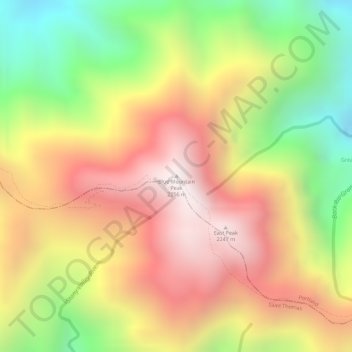
Name: Blue Mountain Peak topographic map, elevation, terrain.
Location: Blue Mountain Peak, Portland, Surrey County, Jamaica (18.04701 -76.57898 18.04711 -76.57888)
Average elevation: 1,808 m
Minimum elevation: 1,278 m
Maximum elevation: 2,234 m
The Blue Mountains are popular for hiking and camping. The traditional Blue Mountain trek is a 7-mile (11 km) hike to the peak and consists of a 3,000-foot (910 m) increase in elevation. Jamaicans prefer to reach the peak at sunrise, thus the 3- to 4-hour hike is usually undertaken in darkness. Since the sky is usually very clear in the mornings, Cuba can be seen in the distance.
Other topographic maps
Click on a map to view its topography, its elevation and its terrain.
St Margaret's Bay
St Margaret's Bay, Portland, Surrey County, Jamaica
Average elevation: 70 m
Orange Vale
Jamaica > Portland > Orange Vale
Orange Vale, Portland, Surrey County, Jamaica
Average elevation: 288 m
Ecclesdown (Bewitched)
Jamaica > Portland > Ecclesdown (Bewitched)
Ecclesdown (Bewitched), Portland, Surrey County, Jamaica
Average elevation: 378 m