
Ras al Hamra topographic map
Interactive map
Click on the map to display elevation.
About this map
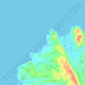
Name: Ras al Hamra topographic map, elevation, terrain.
Location: Ras al Hamra, Muscat, 116, Oman (23.63000 58.48000 23.65000 58.50000)
Average elevation: 11 m
Minimum elevation: 0 m
Maximum elevation: 76 m
Other topographic maps
Click on a map to view its topography, its elevation and its terrain.
Ghala spring water
Ghala spring water, Way 6948, Ghallah, Muscat, Oman
Average elevation: 168 m