
Pantelleria topographic map
Interactive map
Click on the map to display elevation.
About this map
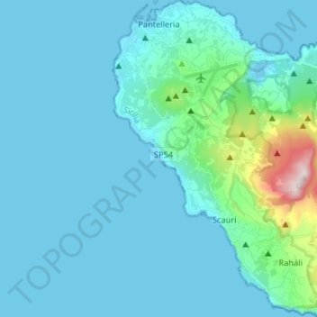
Name: Pantelleria topographic map, elevation, terrain.
Location: Pantelleria, Trapani, Sicily, 91017, Italy (36.73438 11.92586 36.83939 12.05684)
Average elevation: 83 m
Minimum elevation: 0 m
Maximum elevation: 824 m
Pantelleria has a subtropical Mediterranean climate (Köppen: Csa) characterized by very warm to hot, almost rainless and humid summers, very mild and frost-free winters, a powerful seasonal lag and a small diurnal temperature range. The constant sea breezes, moderate the daytime summer temperatures. Coastal Pantelleria (along with Lampedusa and coastal Malta) is one of the very few areas along the Mediterranean Sea coast, which have never recorded frost. Below freezing temperatures and snow only and sporadically occur at Montagna Grande and at higher elevations on the island. Despite the very dry summers and the fairly low annual precipitation, the dry season is noticeably shorter at four months, and the rainy season lasts at least for eight months.
Other topographic maps
Click on a map to view its topography, its elevation and its terrain.
Alcamo Marina
Italy > Sicily > Trapani > Alcamo
Alcamo Marina, Alcamo, Trapani, Sicily, 91011, Italy
Average elevation: 46 m
Borgata Costiera
Italy > Sicily > Trapani > Mazara del Vallo
Borgata Costiera, Mazara del Vallo, Trapani, Sicily, 91026, Italy
Average elevation: 95 m
Mazara del Vallo
Mazara del Vallo, Trapani, Sicily, 91026, Italy
Average elevation: 49 m