
San Cristobal topographic map
Interactive map
Click on the map to display elevation.
About this map
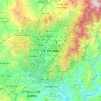
Name: San Cristobal topographic map, elevation, terrain.
Average elevation: 1,220 m
Minimum elevation: 374 m
Maximum elevation: 3,353 m
Other topographic maps
Click on a map to view its topography, its elevation and its terrain.
Parroquia San Juan Bautista
Venezuela > Tachira State > Municipio San Cristóbal
Parroquia San Juan Bautista, Municipio San Cristóbal, Tachira State, 5001, Venezuela
Average elevation: 1,269 m