
Quetzaltenango topographic map
Interactive map
Click on the map to display elevation.
About this map
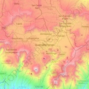
Name: Quetzaltenango topographic map, elevation, terrain.
Location: Quetzaltenango, 09001, Guatemala (14.68682 -91.68002 15.00682 -91.36002)
Average elevation: 2,442 m
Minimum elevation: 885 m
Maximum elevation: 3,739 m
Quetzaltenango has a population of 180,706 (2018 census). The population is about 61% indigenous or Amerindian, 34% Mestizo or ladino and 5% white Latin American. The city is located in a mountain valley at an elevation of 2,330 meters (7,640 feet) above sea level at its lowest part. It may reach above 2,400 meters within the city.