
Make a donation
Gear up for your next adventure:
As an Amazon Associate, this site earns from qualifying purchases at no extra cost to you.
Zugspitze topographic map
Click on the map to display elevation.
Make a donation
Gear up for your next adventure:
As an Amazon Associate, this site earns from qualifying purchases at no extra cost to you.
Zugspitze
The mountain rises eleven kilometres southwest of Garmisch-Partenkirchen and just under six kilometres east of Ehrwald. The border between Germany and Austria runs over the west summit; thus the Zugspitze massif belongs to the German state of Bavaria and the Austrian state of Tyrol. The municipalities responsible for it are Grainau and Ehrwald. To the west the Zugspitze massif drops into the valley of the River Loisach, which flows around the massif towards the northeast in a curve whilst, in the east, the streams of Hammersbach and Partnach have their source. To the south the Gaistal valley and its river, the Leutascher Ache, separate the Wetterstein Mountains from the Mieming Chain. To the north at the foot of the Zugspitze is the lake of Eibsee. The next highest mountain in the area is the Acherkogel (3,008 m or 9,869 ft) in the Stubai Alps, which gives the Zugspitze a topographic isolation value of 24.6 kilometres. The reference point for the prominence is the Parseierspitze (3,036 m or 9,961 ft). In order to climb it from the Zugspitze, a descent to the Fern Pass (1,216 m or 3,990 ft) is required, so that the prominence is 1,746 m (5,728 ft).
Make a donation
Gear up for your next adventure:
As an Amazon Associate, this site earns from qualifying purchases at no extra cost to you.
About this map
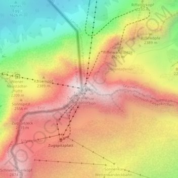
Name: Zugspitze topographic map, elevation, terrain.
Average elevation: 2,300 m
Minimum elevation: 1,513 m
Maximum elevation: 2,952 m
Make a donation
Gear up for your next adventure:
As an Amazon Associate, this site earns from qualifying purchases at no extra cost to you.