
Make a donation
Gear up for your next adventure:
As an Amazon Associate, this site earns from qualifying purchases at no extra cost to you.
Cayey topographic map
Click on the map to display elevation.
Make a donation
Gear up for your next adventure:
As an Amazon Associate, this site earns from qualifying purchases at no extra cost to you.
Cayey
Cayey's climate is humid, rainy and mild compared to lower-elevation areas of the island, the area of the town is nearly 1,500 feet (460 m) high, so the climate is subtropical high. In summer average high Temperatures are around 82 °F to 88 °F and 70 °F to 78 °F in winter, and low around 68 °F to 72 °F in summer and 57 °F to 63 °F in winter. The record maximum temperature is 94 °F (34 °C) and minimum 45 °F (7 °C). The average annual rainfall is 100 inches (2,540 mm) and maximum rainfall record in 24 hours is 20.87 inches (530 mm) of rain.
Make a donation
Gear up for your next adventure:
As an Amazon Associate, this site earns from qualifying purchases at no extra cost to you.
About this map
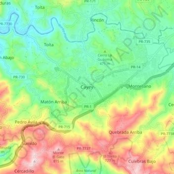
Name: Cayey topographic map, elevation, terrain.
Location: Cayey, Puerto Rico, 00736, United States (18.07269 -66.20628 18.15269 -66.12628)
Average elevation: 489 m
Minimum elevation: 284 m
Maximum elevation: 840 m
Make a donation
Gear up for your next adventure:
As an Amazon Associate, this site earns from qualifying purchases at no extra cost to you.