
Bogatynia topographic map
Interactive map
Click on the map to display elevation.
About this map
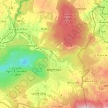
Name: Bogatynia topographic map, elevation, terrain.
Average elevation: 286 m
Minimum elevation: 38 m
Maximum elevation: 559 m
Other topographic maps
Click on a map to view its topography, its elevation and its terrain.
Radzimów
Poland > Lower Silesian Voivodeship > Zgorzelec County
Radzimów, gmina Sulików, Zgorzelec County, Lower Silesian Voivodeship, Poland
Average elevation: 263 m
Pop
Poland > Lower Silesian Voivodeship > Zgorzelec County > Studniska Dolne
Pop, Studniska Dolne, gmina Sulików, Zgorzelec County, Lower Silesian Voivodeship, 59-975, Poland
Average elevation: 217 m