
Luang Namtha topographic map
Interactive map
Click on the map to display elevation.
About this map
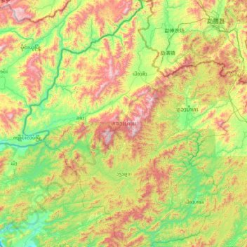
Name: Luang Namtha topographic map, elevation, terrain.
Location: Luang Namtha, Laos (20.30160 100.50917 21.56463 101.77623)
Average elevation: 861 m
Minimum elevation: 366 m
Maximum elevation: 1,992 m
The Nam Ha National Biodiversity Conservation Area (NBCA) has dense forest covering 90% of the area. May to September are the rainy months with average annual rainfall of 1,256 millimetres (49.4 in). December to February are the winter months with temperatures touching as low as 5 °C (41 °F). Heavy fog is common in the morning with warm and sunny middays. The average annual temperature is 25.75 °C (78.35 °F). Vegetation zones in its plains are between 540–1,000 metres (1,770–3,280 ft) elevation, consisting of bamboo, secondary evergreen forest and scrub (introduced by humans). In the Northern Highlands zone, between elevations of 1,000–2,094 metres (3,281–6,870 ft), primary evergreen forest is mixed with secondary forest as well as large patches of Imperata grass. In the Southern Highlands, which range between 1,000–1,572 metres (3,281–5,157 ft) elevations, there is evergreen forest and scrub. Secondary evergreen forests and scrub are found in the Nam Kong area bordering the Chinese border, lying between elevations 600–1,556 metres (1,969–5,105 ft). Wildlife reported from the NBCA are wild cattle such as guar and banteng, Asian wild dogs, tigers, clouded leopard, bears, monkeys and gibbons and also muntjac. The conservation area was initially established covering an area of 677 square kilometres (261 sq mi) in 1991 which was subsequently enlarged to an area 2,244 square kilometres (866 sq mi) (entirely within the province) which borders with Shiang Yong Protected Area in Yunnan province in China. There are 33 large mammals (of which 22 are key species), including Malayan sun bear and black cheeked crested gibbons, and 288 species of birds (of which 18 are key species). It has been designated as an Asian Heritage Site. One issue of concern is of rubber cultivation in large areas.
Other topographic maps
Click on a map to view its topography, its elevation and its terrain.
Thatlouangkang
Laos > Vientiane Prefecture > Xaysetha District > Vientiane Capital
Thatlouangkang, Vientiane Capital, Xaysetha District, Vientiane Prefecture, 01160, Laos
Average elevation: 170 m
Phia-Mai
Laos > Sekong Province > Lam Mam District
Phia-Mai, Lam Mam District, Sekong Province, Laos
Average elevation: 146 m
Xaichamphone District
Xaichamphone District, Bolikhamsai, Laos
Average elevation: 815 m
Pok
Laos > Champasak Province > Phonthong District
Pok, Phonthong District, Champasak Province, Laos
Average elevation: 108 m
Thalouang
Laos > Sekong Province > Lam Mam District
Thalouang, Lam Mam District, Sekong Province, Laos
Average elevation: 155 m
Ban Thap
Laos > Khammouane > Sebangphay District
Ban Thap, Sebangphay District, Khammouane, Laos
Average elevation: 150 m
Phou Phathi
Laos > Houaphanh > Xam Neua District
Phou Phathi, Xam Neua District, Houaphanh, Laos
Average elevation: 1,049 m
Nongkhai
Laos > Sainyabuli Province > Paklai District
Nongkhai, Paklai District, Sainyabuli Province, Laos
Average elevation: 275 m
Dakpam
Laos > Sekong Province > Dak Cheung District
Dakpam, Dak Cheung District, Sekong Province, Laos
Average elevation: 1,263 m
Paksong District
Paksong District, Champasak Province, Laos
Average elevation: 639 m
Luang Namtha
Laos > Luang Namtha > Namtha District
Luang Namtha, Namtha District, Luang Namtha, Laos
Average elevation: 847 m
Vang Vieng
Laos > Vientiane Province > Vangvieng District
Vang Vieng, Vangvieng District, Vientiane Province, 00008, Laos
Average elevation: 308 m
Sanamxai
Laos > Champasak Province > Pak Sé District
Sanamxai, Pak Sé District, Champasak Province, 16000, Laos
Average elevation: 108 m
Vangvieng District
Vangvieng District, Vientiane Province, Laos
Average elevation: 612 m
Miam
Laos > Xiangkhouang Province > Phou Kout District
Miam, Phou Kout District, Xiangkhouang Province, Laos
Average elevation: 890 m
Viengkeo
Laos > Vientiane Province > Vangvieng District
Viengkeo, Vangvieng District, Vientiane Province, 00008, Laos
Average elevation: 256 m
Donkham
Laos > Oudomxay > Houne District
Donkham, Houne District, Oudomxay, Laos
Average elevation: 535 m
Ban Soy
Laos > Khammouane > Boualapha District
Ban Soy, Boualapha District, Khammouane, Laos
Average elevation: 209 m
Muanghian
Laos > Houaphanh > Hiam District
Muanghian, Hiam District, Houaphanh, Laos
Average elevation: 766 m
Navan
Laos > Xiangkhouang Province > Phaxay District
Navan, Phaxay District, Xiangkhouang Province, Laos
Average elevation: 1,134 m
Thoulakhom District
Thoulakhom District, Vientiane Province, Laos
Average elevation: 394 m
Hongsa District
Hongsa District, Sainyabuli Province, Laos
Average elevation: 809 m
Houay Namsai
Laos > Salavan Province > Saravane District > Nathonglouang
Houay Namsai, Nathonglouang, Saravane District, Salavan Province, Laos
Average elevation: 217 m
Sibounheuang
Laos > Vientiane Prefecture > Chanthabuly District > Sibounheuang
Sibounheuang, Vientiane Capital, Chanthabuly District, Vientiane Prefecture, 01009, Laos
Average elevation: 171 m
Mekong River
Laos > Vientiane Province > Xanakham District > Houaytao
Mekong River, Houaytao, Xanakham District, Vientiane Province, Laos
Average elevation: 394 m
Phapho
Laos > Vientiane Prefecture > Sisattanak District > Vientiane Capital > Phapho
Phapho, Vientiane Capital, Sisattanak District, Vientiane Prefecture, 01006, Laos
Average elevation: 170 m
Naka
Laos > Houaphanh > Sop Bao District
Naka, Sop Bao District, Houaphanh, Laos
Average elevation: 337 m
Nounsavath
Laos > Luang Prabang > Luang Prabang District
Nounsavath, Luang Prabang District, Luang Prabang, Laos
Average elevation: 392 m
Paksa
Laos > Luang Prabang > Paksa
Paksa, Xiengngeun District, Luang Prabang, 06000, Laos
Average elevation: 554 m
Pakse
Laos > Champasak Province > Pak Sé District
Pakse, Pak Sé District, Champasak Province, 16000, Laos
Average elevation: 166 m
Phanom
Laos > Luang Prabang > Phanom
Phanom, Luang Prabang District, Luang Prabang, 0600, Laos
Average elevation: 330 m
Nam Ha
Laos > Luang Namtha > Luang Namtha
Nam Ha, Luang Namtha, Namtha District, Luang Namtha, Laos
Average elevation: 874 m
Nam Tam
Laos > Sainyabuli Province > Sayaboury
Nam Tam, Sayaboury, Xayabury District, Sainyabuli Province, Laos
Average elevation: 319 m
Muang Sing
Laos > Luang Namtha > Muang Sing
Muang Sing, Sing District, Luang Namtha, Laos
Average elevation: 663 m
Phone
Laos > Champasak Province > Phone
Phone, Soukhoumma District, Champasak Province, Laos
Average elevation: 96 m
Pakxan
Laos > Bolikhamsai > Pakxan
Pakxan, Paksane District, Bolikhamsai, Laos
Average elevation: 198 m
Khonkaen
Laos > Champasak Province > Champassack District
Khonkaen, Champassack District, Champasak Province, Laos
Average elevation: 153 m