
Sarpang District topographic map
Interactive map
Click on the map to display elevation.
About this map
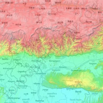
Name: Sarpang District topographic map, elevation, terrain.
Location: Sarpang District, Bhutan (24.42639 87.82007 29.54639 92.94007)
Average elevation: 2,148 m
Minimum elevation: 1 m
Maximum elevation: 8,419 m
Other topographic maps
Click on a map to view its topography, its elevation and its terrain.
Gelephu
Bhutan > Sarpang District > Gakiling Gewog > Gelephu
Gelephu, Gakiling Gewog, Sarpang District, 31101, Bhutan
Average elevation: 242 m
Lekidthang
Bhutan > Sarpang District > Gelegphu Gewog > Lekidthang
Lekidthang, Gelegphu Gewog, Sarpang District, Bhutan
Average elevation: 296 m