
Reinfeld topographic map
Interactive map
Click on the map to display elevation.
About this map
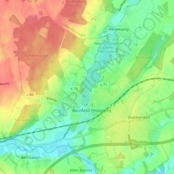
Name: Reinfeld topographic map, elevation, terrain.
Location: Reinfeld, Stormarn, Schleswig-Holstein, 23858, Germany (53.81458 10.44486 53.85889 10.53086)
Average elevation: 30 m
Minimum elevation: -1 m
Maximum elevation: 68 m
Other topographic maps
Click on a map to view its topography, its elevation and its terrain.
Stemwarde
Germany > Schleswig-Holstein > Stormarn > Barsbüttel
Stemwarde, Barsbüttel, Stormarn, Schleswig-Holstein, 21509, Germany
Average elevation: 48 m
Scheidekate
Germany > Schleswig-Holstein > Stormarn > Elmenhorst
Scheidekate, Elmenhorst, Bargteheide-Land, Stormarn, Schleswig-Holstein, 23867, Germany
Average elevation: 40 m
Bargteheide
Germany > Schleswig-Holstein > Stormarn
Bargteheide, Stormarn, Schleswig-Holstein, 22941, Germany
Average elevation: 42 m
Bargfeld-Stegen
Germany > Schleswig-Holstein > Stormarn > Bargfeld-Stegen
Bargfeld-Stegen, Bargteheide-Land, Stormarn, Schleswig-Holstein, 23863, Germany
Average elevation: 36 m
Wilstedt
Germany > Schleswig-Holstein > Stormarn > Wilstedt
Wilstedt, Tangstedt, Itzstedt, Stormarn, Schleswig-Holstein, 22889, Germany
Average elevation: 32 m
Großhansdorf
Germany > Schleswig-Holstein > Stormarn > Großhansdorf
Großhansdorf, Stormarn, Schleswig-Holstein, 22927, Germany
Average elevation: 49 m