
Halewood topographic map
Interactive map
Click on the map to display elevation.
About this map
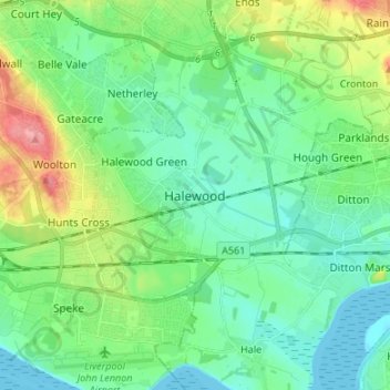
Name: Halewood topographic map, elevation, terrain.
Location: Halewood, North West England, England, L26 2XA, United Kingdom (53.32814 -2.85858 53.40814 -2.77858)
Average elevation: 25 m
Minimum elevation: 0 m
Maximum elevation: 91 m
Other topographic maps
Click on a map to view its topography, its elevation and its terrain.
Halewood
United Kingdom > England > Halewood > Knowsley
Halewood, Knowsley, Liverpool City Region, England, United Kingdom
Average elevation: 23 m
Tarbock Green
United Kingdom > England > Halewood > Knowsley
Tarbock Green, Halewood, Knowsley, Liverpool City Region, England, L35 1QG, United Kingdom
Average elevation: 19 m