
Lac Deligny topographic map
Interactive map
Click on the map to display elevation.
About this map
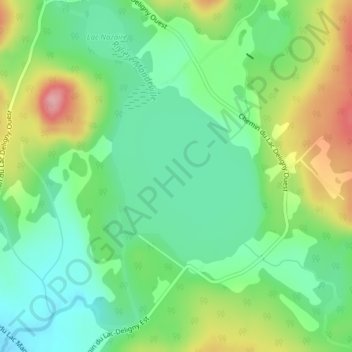
Name: Lac Deligny topographic map, elevation, terrain.
Average elevation: 195 m
Minimum elevation: 146 m
Maximum elevation: 282 m
Other topographic maps
Click on a map to view its topography, its elevation and its terrain.
Lac à la Truite
Canada > Québec > Mandeville
Lac à la Truite, Mandeville, D'Autray, Lanaudière, Québec, Canada
Average elevation: 361 m
Lac de la Panse
Canada > Québec > Mandeville
Lac de la Panse, Sentier Chériore, Mandeville, D'Autray, Lanaudière, Québec, Canada
Average elevation: 435 m