
Smerillo topographic map
Interactive map
Click on the map to display elevation.
About this map
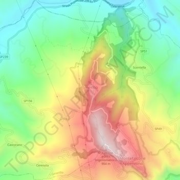
Name: Smerillo topographic map, elevation, terrain.
Location: Smerillo, Fermo, Marche, Italy (42.98615 13.40571 43.02301 13.45584)
Average elevation: 538 m
Minimum elevation: 275 m
Maximum elevation: 881 m
Other topographic maps
Click on a map to view its topography, its elevation and its terrain.
Porto San Giorgio
Porto San Giorgio, Fermo, Marche, 63822, Italy
Average elevation: 33 m
Rovitolo
Italy > Marche > Fermo > Montefortino > Col Martese
Rovitolo, Col Martese, Montefortino, Fermo, Marche, 63858, Italy
Average elevation: 586 m