
Colchester topographic map
Interactive map
Click on the map to display elevation.
About this map
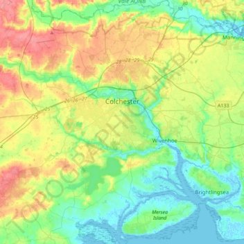
Name: Colchester topographic map, elevation, terrain.
Location: Colchester, Essex, England, United Kingdom (51.76571 0.69938 51.97715 1.02680)
Average elevation: 28 m
Minimum elevation: -2 m
Maximum elevation: 80 m
Essex trails, hiking, mountain biking, running and outdoor activities
Other topographic maps
Click on a map to view its topography, its elevation and its terrain.
Roughtalley's Wood (South) & Epping Forest Woodland Burial Ground
United Kingdom > England > Essex > Epping Forest > Coopersale
Average elevation: 96 m
Nazeing Gate
United Kingdom > England > Essex > Epping Forest > Bumble's Green > Nazeing
Average elevation: 70 m
Passingford Bridge
United Kingdom > England > Essex > Epping Forest > Stapleford Tawney
Average elevation: 53 m
Coles Green
United Kingdom > England > Essex > Uttlesford > Berden > Little London
Average elevation: 100 m
M25 Pollution Control Device
United Kingdom > England > Essex > South Ockendon
Average elevation: 19 m
Wivenhoe Woods
United Kingdom > England > Essex > Colchester > Wivenhoe > Rowhedge
Average elevation: 18 m