
Village of Port Jefferson topographic map
Interactive map
Click on the map to display elevation.
About this map
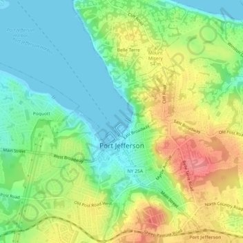
Name: Village of Port Jefferson topographic map, elevation, terrain.
Average elevation: 33 m
Minimum elevation: -1 m
Maximum elevation: 82 m
In 1836 the local leadership initiated the community's transition from a "swampish hamlet" to a busy port town. The 22 acres of the harborfront, which flooded at high tide, were brought to a stable elevation with the construction of a causeway. The village changed its name from "Drowned Meadow" to "Port Jefferson", in honor of Thomas Jefferson.
Other topographic maps
Click on a map to view its topography, its elevation and its terrain.
East Moriches
United States > New York > Suffolk County > Town of Brookhaven > East Moriches
East Moriches, Town of Brookhaven, Suffolk County, New York, 11940, United States
Average elevation: 9 m
Town of Brookhaven
United States > New York > Suffolk County > Town of Brookhaven
Town of Brookhaven, Suffolk County, New York, United States
Average elevation: 10 m
Mastic
United States > New York > Suffolk County > Town of Brookhaven > Mastic
Mastic, Town of Brookhaven, Suffolk County, New York, 11950, United States
Average elevation: 14 m