
Water Island topographic map
Interactive map
Click on the map to display elevation.
About this map
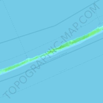
Name: Water Island topographic map, elevation, terrain.
Average elevation: 0 m
Minimum elevation: -1 m
Maximum elevation: 8 m
Other topographic maps
Click on a map to view its topography, its elevation and its terrain.
East Shoreham
United States > New York > Suffolk County > Town of Brookhaven
East Shoreham, Town of Brookhaven, Suffolk County, New York, 11786, United States
Average elevation: 26 m
East Patchogue
United States > New York > Suffolk County > Town of Brookhaven
East Patchogue, Town of Brookhaven, Suffolk County, New York, 11772, United States
Average elevation: 10 m
Blue Point
United States > New York > Suffolk County > Town of Brookhaven
Blue Point, Town of Brookhaven, Suffolk County, New York, 11715, United States
Average elevation: 7 m
Center Moriches
United States > New York > Suffolk County > Town of Brookhaven
Center Moriches, Town of Brookhaven, Suffolk County, New York, 11934, United States
Average elevation: 8 m
Centereach
United States > New York > Suffolk County > Town of Brookhaven
Centereach, Town of Brookhaven, Suffolk County, New York, 11720, United States
Average elevation: 39 m
Medford
United States > New York > Suffolk County > Town of Brookhaven
Medford, Town of Brookhaven, Suffolk County, New York, 11763, United States
Average elevation: 35 m
Sound Beach
United States > New York > Suffolk County > Town of Brookhaven
Sound Beach, Town of Brookhaven, Suffolk County, New York, 11789, United States
Average elevation: 28 m
Selden
United States > New York > Suffolk County > Town of Brookhaven
Selden, Town of Brookhaven, Suffolk County, New York, 11784, United States
Average elevation: 41 m
Rocky Point
United States > New York > Suffolk County > Town of Brookhaven
Rocky Point, Town of Brookhaven, Suffolk County, New York, 11778, United States
Average elevation: 31 m
Middle Island
United States > New York > Suffolk County > Town of Brookhaven
Middle Island, Town of Brookhaven, Suffolk County, New York, 11953, United States
Average elevation: 31 m
Shirley
United States > New York > Suffolk County > Town of Brookhaven
Shirley, Town of Brookhaven, Suffolk County, New York, 11967, United States
Average elevation: 11 m
Farmingville
United States > New York > Suffolk County > Town of Brookhaven
Farmingville, Town of Brookhaven, Suffolk County, New York, 11738, United States
Average elevation: 48 m
Village of Shoreham
United States > New York > Suffolk County > Town of Brookhaven
Village of Shoreham, Town of Brookhaven, Suffolk County, New York, United States
Average elevation: 33 m