
Pegram topographic map
Interactive map
Click on the map to display elevation.
About this map
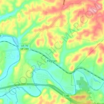
Name: Pegram topographic map, elevation, terrain.
Location: Pegram, Cheatham County, Tennessee, 37143, United States (36.07890 -87.09039 36.13173 -87.02041)
Average elevation: 195 m
Minimum elevation: 144 m
Maximum elevation: 272 m
Other topographic maps
Click on a map to view its topography, its elevation and its terrain.
Gravelotte
United States > Tennessee > Cheatham County > Ashland City
Gravelotte, Ashland City, Cheatham County, Middle Tennessee, Tennessee, United States
Average elevation: 153 m
Germantown
United States > Tennessee > Cheatham County
Germantown, Cheatham County, Middle Tennessee, Tennessee, United States
Average elevation: 199 m
Cheatham Dam
United States > Tennessee > Cheatham County
Cheatham Dam, Cheatham County, Middle Tennessee, Tennessee, United States
Average elevation: 135 m
Ashland City
United States > Tennessee > Cheatham County
Ashland City, Cheatham County, Tennessee, 37015, United States
Average elevation: 166 m
Kingston Springs
United States > Tennessee > Cheatham County
Kingston Springs, Cheatham County, Middle Tennessee, Tennessee, 37082, United States
Average elevation: 186 m
Cheatham State Wildlife Management Area
United States > Tennessee > Cheatham County
Cheatham State Wildlife Management Area, Cheatham County, Tennessee, United States
Average elevation: 205 m