
Kingston topographic map
Interactive map
Click on the map to display elevation.
About this map
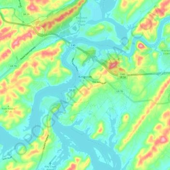
Name: Kingston topographic map, elevation, terrain.
Average elevation: 260 m
Minimum elevation: 221 m
Maximum elevation: 358 m
Other topographic maps
Click on a map to view its topography, its elevation and its terrain.
Harriman
United States > Tennessee > Roane County
Harriman, Roane County, East Tennessee, Tennessee, United States
Average elevation: 291 m
Dogwood Shores
United States > Tennessee > Roane County
Dogwood Shores, Roane County, East Tennessee, Tennessee, United States
Average elevation: 251 m
Rockwood
United States > Tennessee > Roane County
Rockwood, Roane County, East Tennessee, Tennessee, 37854, United States
Average elevation: 331 m
Oliver Springs
United States > Tennessee > Roane County
Oliver Springs, Roane County, East Tennessee, Tennessee, United States
Average elevation: 283 m
Cherokee Hills
United States > Tennessee > Roane County > Kingston
Cherokee Hills, Kingston, Roane County, Tennessee, 37763, United States
Average elevation: 255 m