
Yokohama topographic map
Interactive map
Click on the map to display elevation.
About this map
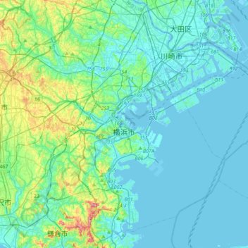
Name: Yokohama topographic map, elevation, terrain.
Location: Yokohama, Kanagawa Prefecture, 231-0017, Japan (35.31250 139.46478 35.59285 139.77693)
Average elevation: 23 m
Minimum elevation: -9 m
Maximum elevation: 146 m
Yokohama has a total area of 437.38 km2 (168.87 sq mi) at an elevation of 5 metres (16 ft) above sea level. It is the capital of Kanagawa Prefecture, bordered to the east by Tokyo Bay and located in the middle of the Kantō plain. The city is surrounded by hills and the characteristic mountain system of the island of Honshū, so its growth has been limited and it has had to gain ground from the sea. This also affects the population density, one of the highest in Japan with 8,500 inhabitants per km2.
Other topographic maps
Click on a map to view its topography, its elevation and its terrain.
Mount Fuji
Japan > Sunto County > Oyama
Mount Fuji, Oyama, Sunto County, Shizuoka Prefecture, Chubu Region, Japan
Average elevation: 3,261 m
Observation Deck (North Terminal)
Observation Deck (North Terminal), Osakaden, Itami, Hyogo Prefecture, Japan
Average elevation: 21 m
Lake Ashi
Japan > Ashigarashimo County > Hakone
Lake Ashi, Hakone, Ashigarashimo County, Kanagawa Prefecture, Japan
Average elevation: 869 m
Nishi Mera
Nishi Mera, Koyu County, Miyazaki Prefecture, Japan
Average elevation: 656 m
Maborikaigan 4-chome Park
Maborikaigan 4-chome Park, Maboricho 3-chome, Yokosuka, Kanagawa Prefecture, 238-8550, Japan
Average elevation: 22 m
Ibaraki
Ibaraki, Higashiibaraki County, Ibaraki Prefecture, 311-3116, Japan
Average elevation: 26 m
Lake Sanaru
Lake Sanaru, Hamamatsu, Shizuoka Prefecture, Chubu Region, Japan
Average elevation: 16 m
Motoyama
Motoyama, Nagaoka County, Kochi Prefecture, 781-3601, Japan
Average elevation: 679 m
Setouchi
Setouchi, Oshima County, Kagoshima Prefecture, Japan
Average elevation: 26 m
Higashishirakawa
Higashishirakawa, Kamo County, Gifu Prefecture, Chubu Region, 509-1392, Japan
Average elevation: 658 m