
City of Ithaca topographic map
Interactive map
Click on the map to display elevation.
About this map
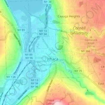
Name: City of Ithaca topographic map, elevation, terrain.
Location: City of Ithaca, Tompkins County, New York, United States (42.41817 -76.52700 42.46694 -76.46999)
Average elevation: 195 m
Minimum elevation: 112 m
Maximum elevation: 347 m
Other topographic maps
Click on a map to view its topography, its elevation and its terrain.
Village of Trumansburg
United States > New York > Tompkins County
Village of Trumansburg, Town of Ulysses, Tompkins County, New York, 14854, United States
Average elevation: 300 m
Town of Danby
United States > New York > Tompkins County
Town of Danby, Tompkins County, New York, United States
Average elevation: 404 m
Town of Newfield
United States > New York > Tompkins County
Town of Newfield, Tompkins County, New York, 14867, United States
Average elevation: 426 m
Buttermilk Falls State Park
United States > New York > Tompkins County > Ithaca > Town of Danby
Buttermilk Falls State Park, Ithaca, Town of Danby, Tompkins County, New York, United States
Average elevation: 269 m
East Ithaca
United States > New York > Tompkins County > Ithaca > East Ithaca
East Ithaca, Ithaca, Tompkins County, New York, United States
Average elevation: 281 m
Town of Ithaca
United States > New York > Tompkins County
Town of Ithaca, Tompkins County, New York, United States
Average elevation: 288 m
Town of Dryden
United States > New York > Tompkins County
Town of Dryden, Tompkins County, New York, United States
Average elevation: 430 m
Waterburg
United States > New York > Tompkins County > Waterburg
Waterburg, Ulysses Town, Tompkins County, New York, 14886, United States
Average elevation: 318 m