
South East England topographic map
Interactive map
Click on the map to display elevation.
About this map
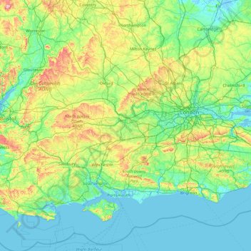
Name: South East England topographic map, elevation, terrain.
Location: South East England, England, United Kingdom (50.57468 -1.95728 52.19632 1.45177)
Average elevation: 69 m
Minimum elevation: -3 m
Maximum elevation: 491 m
Near Weybridge are the UK headquarters of Sony with SSP Group (situated in Byfleet) and Procter & Gamble (next door to each other on The Heights Business Park near the former Brooklands racing circuit) with Kia Motors UK and Petroleum Geo-Services UK, and Gallaher Group (cigarettes) is to the north, next to the Brooklands Museum; to the east is Verint Systems UK on the B374. In Weybridge are the local newspaper group Newsquest, Yamaha Motors UK; BAE Systems Regional Aircraft is on the Brooklands Ind Park off the A318 (since 2001 it has no longer manufactured). On Sprint Ind Est in Byfleet, west of Weybridge, off the A318, AIM Altitude (former Henshalls) make cabin galleys for airliners. The Central Veterinary Laboratory, which is run by the Veterinary Laboratories Agency, with the Animal and Plant Health Agency, is in New Haw to the west on the other side of the M25. Mouchel is in West Byfleet.
Other topographic maps
Click on a map to view its topography, its elevation and its terrain.
London
United Kingdom > England > London
London, Greater London, England, SW1A 2DX, United Kingdom
Average elevation: 42 m
London
London, Greater London, England, United Kingdom
Average elevation: 66 m
Birmingham
Birmingham, West Midlands Combined Authority, England, United Kingdom
Average elevation: 138 m
Bristol
United Kingdom > England > City of Bristol
Bristol, City of Bristol, West of England, England, United Kingdom
Average elevation: 55 m
Nottingham
United Kingdom > England > Nottinghamshire
Nottingham, England, United Kingdom
Average elevation: 56 m
East of England
East of England, England, United Kingdom
Average elevation: 39 m
Sheffield
Sheffield, South Yorkshire, England, United Kingdom
Average elevation: 168 m
Greater Manchester
Greater Manchester, England, United Kingdom
Average elevation: 141 m
Lake District National Park
Lake District National Park, England, United Kingdom
Average elevation: 206 m
Cambridge
United Kingdom > England > Cambridge
Cambridge, Cambridgeshire, East of England, England, United Kingdom
Average elevation: 18 m
Oxford
United Kingdom > England > Oxfordshire
Oxford, Oxfordshire, England, United Kingdom
Average elevation: 81 m
Norwich
United Kingdom > England > Norfolk
Norwich, Norfolk, England, United Kingdom
Average elevation: 28 m
Bedford
United Kingdom > England > Bedford
Bedford, England, MK40 1SU, United Kingdom
Average elevation: 37 m
Brighton
United Kingdom > England > Brighton and Hove
Brighton, Brighton and Hove, England, United Kingdom
Average elevation: 64 m
Newcastle upon Tyne
Newcastle upon Tyne, North of Tyne, England, United Kingdom
Average elevation: 57 m
Lincolnshire
Lincolnshire, East Midlands, England, United Kingdom
Average elevation: 28 m
Liverpool
Liverpool, Liverpool City Region, England, United Kingdom
Average elevation: 26 m
Plymouth
United Kingdom > England > Devon > Plymouth
Plymouth, Devon, South West England, England, PL1 1HH, United Kingdom
Average elevation: 81 m
Hampshire
Hampshire, South East, England, United Kingdom
Average elevation: 73 m
Winchester
United Kingdom > England > Hampshire
Winchester, Hampshire, England, United Kingdom
Average elevation: 73 m
Bath
United Kingdom > England > Bath and North East Somerset
Bath, Bath and North East Somerset, West of England, England, United Kingdom
Average elevation: 100 m
Chesterfield
United Kingdom > England > Derbyshire
Chesterfield, Derbyshire, England, United Kingdom
Average elevation: 127 m
Cambridge
United Kingdom > England > Cambridgeshire
Cambridge, Cambridgeshire, Cambridgeshire and Peterborough, England, United Kingdom
Average elevation: 18 m
City of Durham
United Kingdom > England > County Durham > Durham
City of Durham, Durham, County Durham, North East, England, United Kingdom
Average elevation: 76 m
West Yorkshire
West Yorkshire, England, United Kingdom
Average elevation: 172 m
North West England
North West England, England, United Kingdom
Average elevation: 118 m
Grimsby
United Kingdom > England > North East Lincolnshire
Grimsby, North East Lincolnshire, England, DN31 1NR, United Kingdom
Average elevation: 6 m
Orpington
Orpington, Greater London, England, BR6 0NA, United Kingdom
Average elevation: 88 m
Woking
United Kingdom > England > Surrey
Woking, Surrey, England, United Kingdom
Average elevation: 38 m
Seal Chart
United Kingdom > England > Kent > Sevenoaks > Styants Bottom
Seal Chart, Styants Bottom, Seal, Sevenoaks, Kent, England, TN15 0DZ, United Kingdom
Average elevation: 143 m
North Yorkshire
North Yorkshire, Yorkshire and the Humber, England, United Kingdom
Average elevation: 153 m
Berkshire
United Kingdom > England > West Berkshire
Berkshire, West Berkshire, England, United Kingdom
Average elevation: 100 m
Milton Keynes
United Kingdom > England > Milton Keynes > Milton Keynes
Milton Keynes, South East England, England, MK9 3AF, United Kingdom
Average elevation: 81 m
Lincolnshire Wolds AONB
United Kingdom > England > Lincolnshire
Lincolnshire Wolds AONB, Lincolnshire, England, United Kingdom
Average elevation: 48 m
City of Bristol
City of Bristol, West of England, England, United Kingdom
Average elevation: 80 m
Maidenhead
United Kingdom > England > Royal Borough of Windsor and Maidenhead
Maidenhead, Royal Borough of Windsor and Maidenhead, England, SL6 1QB, United Kingdom
Average elevation: 41 m
Manchester
Manchester, Greater Manchester, England, United Kingdom
Average elevation: 66 m
Ipswich
United Kingdom > England > Suffolk
Ipswich, Suffolk, England, United Kingdom
Average elevation: 29 m
Chelmsford
United Kingdom > England > Essex
Chelmsford, Essex, England, United Kingdom
Average elevation: 54 m