
Bloomfield Township topographic map
Interactive map
Click on the map to display elevation.
About this map
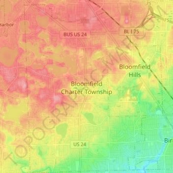
Name: Bloomfield Township topographic map, elevation, terrain.
Location: Bloomfield Township, Oakland County, Michigan, United States (42.52937 -83.32514 42.62100 -83.20633)
Average elevation: 269 m
Minimum elevation: 217 m
Maximum elevation: 309 m
Other topographic maps
Click on a map to view its topography, its elevation and its terrain.
Farmington Hills
United States > Michigan > Oakland County
Farmington Hills, Oakland County, Michigan, United States
Average elevation: 246 m
Rochester Hills
United States > Michigan > Oakland County
Rochester Hills, Oakland County, Michigan, United States
Average elevation: 250 m
Lake Orion
United States > Michigan > Oakland County
Lake Orion, Oakland County, Michigan, 48362, United States
Average elevation: 303 m
Highland Charter Township
United States > Michigan > Oakland County
Highland Charter Township, Oakland County, Michigan, United States
Average elevation: 314 m
Independence Charter Township
United States > Michigan > Oakland County
Independence Charter Township, Oakland County, Michigan, United States
Average elevation: 318 m
Troy
United States > Michigan > Oakland County
Troy, Oakland County, Michigan, United States
Average elevation: 221 m
Southfield
United States > Michigan > Oakland County
Southfield, Oakland County, Michigan, United States
Average elevation: 210 m
Novi
United States > Michigan > Oakland County
Novi, Oakland County, Michigan, United States
Average elevation: 280 m
Huron Heights
United States > Michigan > Oakland County > Waterford Charter Township
Huron Heights, Waterford Charter Township, Oakland County, Michigan, 48328, United States
Average elevation: 292 m
Springfield Charter Township
United States > Michigan > Oakland County
Springfield Charter Township, Oakland County, Michigan, 48350, United States
Average elevation: 318 m
Oxford Charter Township
United States > Michigan > Oakland County
Oxford Charter Township, Oakland County, Michigan, 48371, United States
Average elevation: 325 m
Keego Harbor
United States > Michigan > Oakland County
Keego Harbor, Oakland County, Michigan, United States
Average elevation: 286 m
Bloomfield
United States > Michigan > Oakland County > Birmingham
Bloomfield, Birmingham, Oakland County, Michigan, 35075, United States
Average elevation: 231 m
Union Lake
United States > Michigan > Oakland County > White Lake Charter Township
Union Lake, White Lake Charter Township, Oakland County, Michigan, 48386, United States
Average elevation: 290 m
Birmingham
United States > Michigan > Oakland County
Birmingham, Oakland County, Michigan, United States
Average elevation: 234 m
Davisburg
United States > Michigan > Oakland County
Davisburg, Oakland County, Michigan, 48350, United States
Average elevation: 309 m
Commerce Township
United States > Michigan > Oakland County
Commerce Township, Oakland County, Michigan, 48382, United States
Average elevation: 286 m
West Bloomfield Charter Township
United States > Michigan > Oakland County
West Bloomfield Charter Township, Oakland County, Michigan, United States
Average elevation: 286 m
Village of Clarkston
United States > Michigan > Oakland County
Village of Clarkston, Oakland County, Michigan, United States
Average elevation: 308 m
Ortonville State Recreation Area
United States > Michigan > Oakland County
Ortonville State Recreation Area, Hadley Township, Oakland County, Michigan, United States
Average elevation: 305 m
Clawson
United States > Michigan > Oakland County
Clawson, Oakland County, Michigan, 48017, United States
Average elevation: 206 m
Milford Township
United States > Michigan > Oakland County
Milford Township, Oakland County, Michigan, United States
Average elevation: 296 m
Rochester
United States > Michigan > Oakland County > Rochester
Rochester, Oakland County, Michigan, United States
Average elevation: 242 m
Lyon Township
United States > Michigan > Oakland County
Lyon Township, Oakland County, Michigan, 48165, United States
Average elevation: 291 m
Rochester Hills
United States > Michigan > Oakland County > Rochester Hills
Rochester Hills, Oakland County, Michigan, 48309, United States
Average elevation: 246 m
Auburn Hills
United States > Michigan > Oakland County
Auburn Hills, Oakland County, Michigan, 48326, United States
Average elevation: 284 m
Berkley
United States > Michigan > Oakland County > Berkley
Berkley, Oakland County, Michigan, United States
Average elevation: 210 m
Waterford Township
United States > Michigan > Oakland County > Waterford Township
Waterford Township, Oakland County, Michigan, United States
Average elevation: 294 m
Troy
United States > Michigan > Oakland County > Troy
Troy, Oakland County, Michigan, 48085:48098, United States
Average elevation: 229 m
Beverly Hills
United States > Michigan > Oakland County > Beverly Hills
Beverly Hills, Southfield Township, Oakland County, Michigan, United States
Average elevation: 224 m
Royal Oak
United States > Michigan > Oakland County > Royal Oak
Royal Oak, Oakland County, Michigan, United States
Average elevation: 203 m
Pontiac
United States > Michigan > Oakland County > Pontiac
Pontiac, Oakland County, Michigan, United States
Average elevation: 290 m
Oakland Charter Township
United States > Michigan > Oakland County
Oakland Charter Township, Oakland County, Michigan, United States
Average elevation: 284 m