
Kinale ward topographic map
Interactive map
Click on the map to display elevation.
About this map
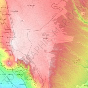
Name: Kinale ward topographic map, elevation, terrain.
Location: Kinale ward, Lari, Kiambu, Central Kenya, Kenya (-0.96732 36.55541 -0.75823 36.74695)
Average elevation: 2,458 m
Minimum elevation: 1,839 m
Maximum elevation: 2,747 m
Other topographic maps
Click on a map to view its topography, its elevation and its terrain.
Kijabe
Kenya > Kiambu > Lari > Kijabe ward
Kijabe, Kijabe ward, Lari, Kiambu, Central Kenya, 00221, Kenya
Average elevation: 2,233 m