
Stanwood topographic map
Interactive map
Click on the map to display elevation.
About this map
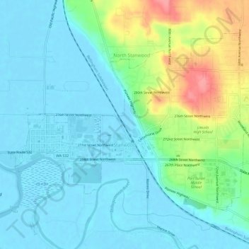
Name: Stanwood topographic map, elevation, terrain.
Location: Stanwood, Snohomish County, Washington, United States (48.23108 -122.37780 48.25961 -122.31922)
Average elevation: 20 m
Minimum elevation: -2 m
Maximum elevation: 83 m
The city is located at the mouth of the Stillaguamish River, where it flows into Port Susan, an arm of the Puget Sound, and Skagit Bay, the mouth of the Skagit River. To the west is Davis Slough, which separates Stanwood from Camano Island and forms the border between Snohomish and Island counties. Elevations in Stanwood range from 2 feet (0.61 m) above sea level near the Stillaguamish River to 190 feet (58 m) in the northeastern hills. The city is home to five creeks and drainage basins that flow into the Stillaguamish River and Puget Sound: Church Creek, Douglas Creek, Irvine Slough, the Skagit River, and the Stillaguamish River. The Stanwood area was formed during the Pleistocene glaciation and was further shaped through the rise and fall of the sea level as well as sedimentary deposits from the Skagit and Stillaguamish rivers.
Other topographic maps
Click on a map to view its topography, its elevation and its terrain.
Lake Stevens
United States > Washington > Snohomish County > Lake Stevens
Lake Stevens, Snohomish County, Washington, United States
Average elevation: 82 m
Everett
United States > Washington > Snohomish County
Everett, Snohomish County, Washington, United States
Average elevation: 66 m
Index
United States > Washington > Snohomish County
Index, Snohomish County, Washington, United States
Average elevation: 366 m
Weallup Lake
United States > Washington > Snohomish County
Weallup Lake, Snohomish County, Washington, United States
Average elevation: 112 m
Hyland
United States > Washington > Snohomish County > Lochsloy
Hyland, Lochsloy, Snohomish County, Washington, 98258, United States
Average elevation: 97 m
Mountlake Terrace
United States > Washington > Snohomish County
Mountlake Terrace, Snohomish County, Washington, 98043, United States
Average elevation: 121 m
Arlington Heights
United States > Washington > Snohomish County
Arlington Heights, Snohomish County, Washington, United States
Average elevation: 136 m
Whitehorse Mountain
United States > Washington > Snohomish County
Whitehorse Mountain, Snohomish County, Washington, United States
Average elevation: 1,430 m
Woodway
United States > Washington > Snohomish County
Woodway, Snohomish County, Washington, United States
Average elevation: 58 m
Verlot
United States > Washington > Snohomish County > Verlot
Verlot, Snohomish County, Washington, United States
Average elevation: 712 m
Devils Peak
United States > Washington > Snohomish County
Devils Peak, Snohomish County, Washington, United States
Average elevation: 1,198 m
Lynnwood
United States > Washington > Snohomish County
Lynnwood, Snohomish County, Washington, 98037, United States
Average elevation: 121 m
North Creek
United States > Washington > Snohomish County > North Creek
North Creek, Snohomish County, Washington, 98021, United States
Average elevation: 103 m
Lynnwood
United States > Washington > Snohomish County > Lynnwood > Lynnwood
Lynnwood, Snohomish County, Washington, 98036, United States
Average elevation: 112 m
Mill Creek
United States > Washington > Snohomish County > Mill Creek > Mill Creek
Mill Creek, Snohomish County, Washington, 98012, United States
Average elevation: 129 m
Hartford
United States > Washington > Snohomish County > Lake Stevens > Hartford
Hartford, Lake Stevens, Snohomish County, Washington, 98358, United States
Average elevation: 82 m
Edmonds
United States > Washington > Snohomish County
Edmonds, Snohomish County, Washington, United States
Average elevation: 44 m
Scimitar Glacier
United States > Washington > Snohomish County
Scimitar Glacier, Snohomish County, Washington, United States
Average elevation: 2,346 m
Everett
United States > Washington > Snohomish County > Everett
Everett, Snohomish County, Washington, 98120, United States
Average elevation: 67 m
Snohomish
United States > Washington > Snohomish County > Snohomish
Snohomish, Snohomish County, Washington, 98291, United States
Average elevation: 39 m
Sultan
United States > Washington > Snohomish County
Sultan, Snohomish County, Washington, 98294, United States
Average elevation: 78 m
Three Lakes
United States > Washington > Snohomish County
Three Lakes, Snohomish County, Washington, United States
Average elevation: 131 m
Monroe
United States > Washington > Snohomish County
Monroe, Snohomish County, Washington, 98272, United States
Average elevation: 49 m
Darrington
United States > Washington > Snohomish County
Darrington, Snohomish County, Washington, United States
Average elevation: 190 m
Ranier Vista
United States > Washington > Snohomish County > Marysville
Ranier Vista, Marysville, Snohomish County, Washington, United States
Average elevation: 14 m
Marysville
United States > Washington > Snohomish County
Marysville, Snohomish County, Washington, United States
Average elevation: 72 m
Arlington
United States > Washington > Snohomish County
Arlington, Snohomish County, Washington, United States
Average elevation: 60 m
Mill Creek
United States > Washington > Snohomish County
Mill Creek, Snohomish County, Washington, United States
Average elevation: 130 m