
Shabramant topographic map
Interactive map
Click on the map to display elevation.
About this map
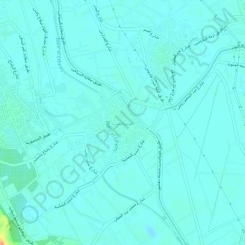
Name: Shabramant topographic map, elevation, terrain.
Location: Shabramant, Giza, 12947, Egypt (29.92077 31.17012 29.96077 31.21012)
Average elevation: 20 m
Minimum elevation: 14 m
Maximum elevation: 55 m
Other topographic maps
Click on a map to view its topography, its elevation and its terrain.
Sheikh Zayed City
Egypt > Giza > Sheikh Zayed City
Sheikh Zayed City, Giza, 12593, Egypt
Average elevation: 103 m
El Hassana Dome Protectorate
Egypt > Giza > Sheikh Zayed
El Hassana Dome Protectorate, Sheikh Zayed, Giza, Egypt
Average elevation: 108 m
Al Hosary park
Egypt > Giza > Sixth of October
Al Hosary park, Neighborhood 1, 8th District, Sixth of October, Giza, Egypt
Average elevation: 184 m
Nazlet Al Siman and Al Sisi
Egypt > Giza > Remaya Square
Nazlet Al Siman and Al Sisi, Remaya Square, Giza, Egypt
Average elevation: 42 m