
Georgia topographic map
Interactive map
Click on the map to display elevation.
About this map
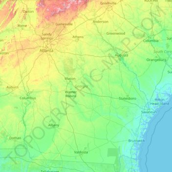
Name: Georgia topographic map, elevation, terrain.
Location: Georgia, United States (30.35566 -85.60517 35.00068 -80.75143)
Average elevation: 136 m
Minimum elevation: -3 m
Maximum elevation: 1,368 m
Georgia is defined by a diversity of landscapes, flora, and fauna. The state's northernmost regions include the Blue Ridge Mountains, part of the larger Appalachian Mountain system. The Piedmont plateau extends from the foothills of the Blue Ridge south to the Fall Line, an escarpment to the Coastal Plain defining the state's southern region. Georgia's highest point is Brasstown Bald at 4,784 feet (1,458 m) above sea level; the lowest is the Atlantic Ocean. With the exception of some high-altitude areas in the Blue Ridge, the entirety of the state has a humid subtropical climate. Of the states entirely east of the Mississippi River, Georgia is the largest in land area.
Other topographic maps
Click on a map to view its topography, its elevation and its terrain.
Santa Cruz
United States > California > Santa Cruz County
Santa Cruz, Santa Cruz County, California, United States
Average elevation: 89 m
Albuquerque
United States > New Mexico > Bernalillo County
Albuquerque, Bernalillo County, New Mexico, United States
Average elevation: 1,688 m
Allegheny County
Allegheny County, Pennsylvania, United States
Average elevation: 325 m
Cape Cod
United States > Massachusetts > Plymouth County
Cape Cod, Plymouth County, Massachusetts, United States
Average elevation: 2 m
Aurora
United States > Colorado > Adams County
Aurora, Adams County, Colorado, United States
Average elevation: 1,691 m
Indianapolis
United States > Indiana > Indianapolis
Indianapolis, Marion County, Indiana, 46204, United States
Average elevation: 241 m
Tampa
United States > Florida > Hillsborough County
Tampa, Hillsborough County, Florida, United States
Average elevation: 11 m
Brooklyn
United States > New York > New York
Brooklyn, Kings County, New York, United States
Average elevation: 9 m
Knoxville
United States > Tennessee > Knox County
Knoxville, Knox County, East Tennessee, Tennessee, United States
Average elevation: 307 m
Oakland County
Oakland County, Michigan, United States
Average elevation: 282 m
Jacksonville
United States > Florida > Duval County
Jacksonville, Duval County, Florida, United States
Average elevation: 10 m
Waltham
United States > Massachusetts > Middlesex County
Waltham, Middlesex County, Massachusetts, United States
Average elevation: 48 m
Yosemite National Park
Yosemite National Park, California, United States
Average elevation: 2,337 m
Atlantic City
United States > New Jersey > Atlantic County
Atlantic City, Atlantic County, New Jersey, 08401, United States
Average elevation: 1 m
Bonita Springs
United States > Florida > Lee County
Bonita Springs, Lee County, Florida, United States
Average elevation: 5 m
Annapolis
United States > Maryland > Anne Arundel County
Annapolis, Anne Arundel County, Maryland, United States
Average elevation: 8 m
Manhattan
United States > New York > New York County > New York
Manhattan, New York County, New York, United States
Average elevation: 16 m
Spokane
United States > Washington > Spokane County
Spokane, Spokane County, Washington, United States
Average elevation: 655 m
Worcester
United States > Massachusetts > Worcester County
Worcester, Worcester County, Massachusetts, United States
Average elevation: 186 m
Ridgefield
United States > Connecticut > Western Connecticut Planning Region
Ridgefield, Western Connecticut Planning Region, Connecticut, 06877, United States
Average elevation: 183 m
Hudson River
Hudson River, New Jersey, 12834:12871, United States
Average elevation: 297 m
Pierce County
Pierce County, Washington, United States
Average elevation: 498 m