
Pita topographic map
Interactive map
Click on the map to display elevation.
About this map
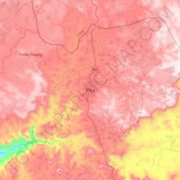
Name: Pita topographic map, elevation, terrain.
Location: Pita, Pita Prefecture, Mamou Region, Guinea (10.89646 -12.55505 11.21646 -12.23505)
Average elevation: 937 m
Minimum elevation: 294 m
Maximum elevation: 1,235 m
Th geographical coordinates of the town are 11°03'16.0"N, 12°23'46.0"W (Latitude:11.054444; Longitude:-12.396111). The town is located at an average elevation of 972.6 metres (3,191 ft) above mean sea level.