
Make a donation
Gear up for your next adventure:
As an Amazon Associate, this site earns from qualifying purchases at no extra cost to you.
Mount Washington topographic map
Click on the map to display elevation.
Make a donation
Gear up for your next adventure:
As an Amazon Associate, this site earns from qualifying purchases at no extra cost to you.
Mount Washington
Mount Washington, also known as Agiocochook, is an ultra-prominent mountain in the state of New Hampshire. It is the highest peak in the Northeastern United States at 6,288.2 ft (1,916.6 m) and the most topographically prominent mountain east of the Mississippi River.
Make a donation
Gear up for your next adventure:
As an Amazon Associate, this site earns from qualifying purchases at no extra cost to you.
About this map
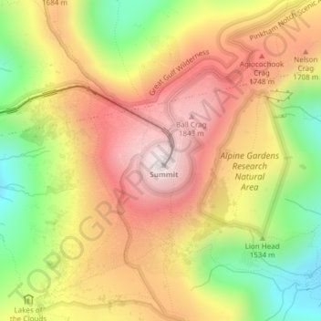
Name: Mount Washington topographic map, elevation, terrain.
Average elevation: 1,568 m
Minimum elevation: 1,161 m
Maximum elevation: 1,911 m
Make a donation
Gear up for your next adventure:
As an Amazon Associate, this site earns from qualifying purchases at no extra cost to you.
Other topographic maps
Click on a map to view its topography, its elevation and its terrain.
Pittsburg
United States > New Hampshire > Coos County
The highest point in Pittsburg is the summit of Stub Hill, at 3,627 feet (1,106 m). Mount Magalloway, elevation 3,383 feet (1,031 m), is a prominent summit reachable by hiking trail.
Average elevation: 522 m
Make a donation
Gear up for your next adventure:
As an Amazon Associate, this site earns from qualifying purchases at no extra cost to you.
Sargent's Purchase
United States > New Hampshire > Coos County
The township is in the White Mountains of New Hampshire and includes the summit of Mount Washington, the highest mountain in New England, with an elevation of 6,288 feet (1,917 m) above sea level. Other notable summits within the purchase include Mount Monroe, at 5,380 feet (1,640 m); Mount Isolation, at 4,004…
Average elevation: 759 m
Gorham
United States > New Hampshire > Coos County
The highest point in Gorham is along its western border, on a spur of Mount Madison, where the elevation reaches 3,030 feet (920 m) above sea level. While Gorham itself is surrounded by larger mountains, a small prominent peak within the town is 2,400-foot (730 m) high Pine Mountain.
Average elevation: 477 m
Make a donation
Gear up for your next adventure:
As an Amazon Associate, this site earns from qualifying purchases at no extra cost to you.
Jefferson
United States > New Hampshire > Coos County
Jefferson is located on U.S. Route 2 between Lancaster and Randolph, near the midpoint between the Vermont and Maine borders. Set astride the broad Israel River valley, the town commands remarkable views of the Presidential Range and other White Mountain summits. Mount Starr King, with an elevation of 3,907…
Average elevation: 493 m
Make a donation
Gear up for your next adventure:
As an Amazon Associate, this site earns from qualifying purchases at no extra cost to you.
Dixville
United States > New Hampshire > Coos County
According to the United States Census Bureau, the township has a total area of 49.2 square miles (127.3 km2), of which 49.0 square miles (126.9 km2) are land and 0.2 square miles (0.4 km2), or 0.35%, are water. Dixville Notch is in the southwest part of the township. With an elevation of 1,887 feet (575 m)…
Average elevation: 635 m
Green's Grant
United States > New Hampshire > Coos County
According to the United States Census Bureau, the grant has a total area of 3.7 square miles (9.5 km2), of which 1.8 acres (7,256 m2), or 0.08%, are covered by water. The Peabody River, a northward-flowing tributary of the Androscoggin River, runs through the center of the grant, joined by its tributaries,…
Average elevation: 558 m
Errol
United States > New Hampshire > Coos County
According to the United States Census Bureau, the town has a total area of 69.5 square miles (179.9 km2), of which 60.3 square miles (156.3 km2) are land and 9.1 square miles (23.5 km2) are water, comprising 13.09% of the town. The Androscoggin River begins in Errol, where the Magalloway River joins the outlet…
Average elevation: 453 m
Clarksville
United States > New Hampshire > Coos County
According to the United States Census Bureau, the town has a total area of 62.4 square miles (161.5 km2), of which 60.3 square miles (156.3 km2) are land and 2.0 square miles (5.2 km2) are water, comprising 3.24% of the town. The highest point in Clarksville is Crystal Mountain, at 3,230 feet (980 m) above sea…
Average elevation: 570 m
Make a donation
Gear up for your next adventure:
As an Amazon Associate, this site earns from qualifying purchases at no extra cost to you.
Clarksville
United States > New Hampshire > Coos County
According to the United States Census Bureau, the town has a total area of 62.4 square miles (161.5 km2), of which 60.3 square miles (156.3 km2) are land and 2.0 square miles (5.2 km2) are water, comprising 3.24% of the town. The highest point in Clarksville is Crystal Mountain, at 3,230 feet (980 m) above sea…
Average elevation: 570 m
Lancaster
United States > New Hampshire > Coos County
Just south of the village center is Mount Prospect, summer home to Senator John W. Weeks, who sponsored congressional legislation creating White Mountain National Forest. In 1910, he purchased several farms to assemble the 420-acre (170 ha) estate. It is now Weeks State Park, which features a fire lookout and…
Average elevation: 372 m
Make a donation
Gear up for your next adventure:
As an Amazon Associate, this site earns from qualifying purchases at no extra cost to you.
Pittsburg
United States > New Hampshire > Coos County
The highest point in Pittsburg is the summit of Stub Hill, at 3,627 feet (1,106 m). Mount Magalloway, elevation 3,383 feet (1,031 m), is a prominent summit reachable by hiking trail.
Average elevation: 522 m
Jefferson
United States > New Hampshire > Coos County
Jefferson is located on U.S. Route 2 between Lancaster and Randolph, west of the midpoint between the Vermont and Maine borders. Set astride the broad Israel River valley, the town commands remarkable views of the Presidential Range and other White Mountain summits. Mount Starr King, with an elevation of 3,907…
Average elevation: 494 m
Make a donation
Gear up for your next adventure:
As an Amazon Associate, this site earns from qualifying purchases at no extra cost to you.
Colebrook
United States > New Hampshire > Coos County
According to the United States Census Bureau, the town of Colebrook has a total area of 40.7 square miles (105.5 km2), of which 40.5 square miles (104.9 km2) are land and 0.2 square miles (0.5 km2) are water, comprising 0.51% of the town. The highest point in Colebrook is Van Dyck Mountain, elevation 2,760…
Average elevation: 476 m
Make a donation
Gear up for your next adventure:
As an Amazon Associate, this site earns from qualifying purchases at no extra cost to you.
Make a donation
Gear up for your next adventure:
As an Amazon Associate, this site earns from qualifying purchases at no extra cost to you.
Jefferson
United States > New Hampshire > Coos County
Jefferson is located on U.S. Route 2 between Lancaster and Randolph, west of the midpoint between the Vermont and Maine borders. Set astride the broad Israel River valley, the town commands remarkable views of the Presidential Range and other White Mountain summits. Mount Starr King, with an elevation of 3,907…
Average elevation: 493 m
Gorham
United States > New Hampshire > Coos County
The highest point in Gorham is along its western border, on a spur of Mount Madison, where the elevation reaches 3,030 feet (920 m) above sea level. While Gorham itself is surrounded by larger mountains, a small prominent peak within the town is 2,400-foot (730 m) high Pine Mountain.
Average elevation: 477 m
Make a donation
Gear up for your next adventure:
As an Amazon Associate, this site earns from qualifying purchases at no extra cost to you.