
Make a donation
Gear up for your next adventure:
As an Amazon Associate, this site earns from qualifying purchases at no extra cost to you.
Sheraro topographic map
Click on the map to display elevation.
Make a donation
Gear up for your next adventure:
As an Amazon Associate, this site earns from qualifying purchases at no extra cost to you.
Sheraro
Sheraro (Tigrinya: ሸራሮ) is a town and separate woreda in Tigray, Ethiopia. It is located in the North Western Zone of the Tigray Region, at an elevation of 1246 meters above sea level. It is the administrative center of Tahtay Adiyabo. It is near the border with Eritrea.
Make a donation
Gear up for your next adventure:
As an Amazon Associate, this site earns from qualifying purchases at no extra cost to you.
About this map
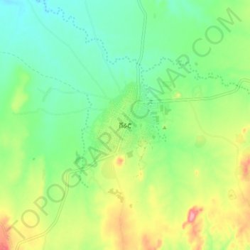
Name: Sheraro topographic map, elevation, terrain.
Location: Sheraro, North Western Tigray, Tigray, Ethiopia (14.35306 37.73140 14.43306 37.81140)
Average elevation: 1,041 m
Minimum elevation: 1,001 m
Maximum elevation: 1,113 m
Make a donation
Gear up for your next adventure:
As an Amazon Associate, this site earns from qualifying purchases at no extra cost to you.
Other topographic maps
Click on a map to view its topography, its elevation and its terrain.