
Alcanar topographic map
Interactive map
Click on the map to display elevation.
About this map
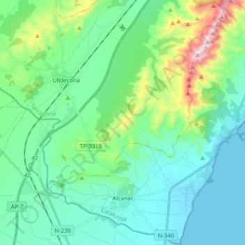
Name: Alcanar topographic map, elevation, terrain.
Location: Alcanar, Montsià, Tarragona, Catalonië, 43530, Spanje (40.52298 0.43743 40.63232 0.58113)
Average elevation: 155 m
Minimum elevation: -2 m
Maximum elevation: 749 m
In 1978 kwam de gemeente in het nieuws door een explosie van een tankwagen met vloeibaar propeen ter hoogte van de ingang van de camping Los Alfaques. Hierbij vielen ten minste 215 doden.
Other topographic maps
Click on a map to view its topography, its elevation and its terrain.