
Region Südliche Ägäis topographic map
Interactive map
Click on the map to display elevation.
About this map
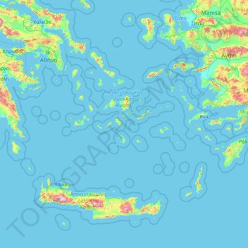
Name: Region Südliche Ägäis topographic map, elevation, terrain.
Location: Region Südliche Ägäis, Ägäis, Griechenland (35.23795 24.06581 38.09832 29.72970)
Average elevation: 84 m
Minimum elevation: -2 m
Maximum elevation: 2,336 m
Other topographic maps
Click on a map to view its topography, its elevation and its terrain.
Rhodos
Griechenland > Ägäis > Rhodos
Rhodos, Δήμος Ρόδου, Regionalbezirk Rhodos, Region Südliche Ägäis, Ägäis, 85100, Griechenland
Average elevation: 29 m
Naxos
Griechenland > Ägäis > Regionalbezirk Naxos
Naxos, Regionalbezirk Naxos, Region Südliche Ägäis, Ägäis, Griechenland
Average elevation: 112 m
Rhodos
Griechenland > Ägäis > Rhodos
Rhodos, Δήμος Ρόδου, Regionalbezirk Rhodos, Region Südliche Ägäis, Ägäis, 85100, Griechenland
Average elevation: 67 m
Κλίμα
Κλίμα, Δήμος Κιμώλου, Regionalbezirk Milos, Region Südliche Ägäis, Ägäis, Griechenland
Average elevation: 13 m
Δημοτική Ενότητα Θήρας
Griechenland > Ägäis > Δημοτική Ενότητα Θήρας
Δημοτική Ενότητα Θήρας, Δήμος Θήρας, Regionalbezirk Thira, Region Südliche Ägäis, Ägäis, Griechenland
Average elevation: 12 m
Klima
Griechenland > Ägäis > Klima
Klima, Gemeinde Samos, Regionalbezirk Samos, Region Nördliche Ägäis, Ägäis, 83100, Griechenland
Average elevation: 62 m
Andros
Andros, Gemeinde Andros, Regionalbezirk Andros, Region Südliche Ägäis, Ägäis, Griechenland
Average elevation: 83 m
Gyali
Gyali, Δήμος Νισύρου, Regionalbezirk Kos, Region Südliche Ägäis, Ägäis, Griechenland
Average elevation: 12 m
Nisyros
Nisyros, Δήμος Νισύρου, Regionalbezirk Kos, Region Südliche Ägäis, Ägäis, 85303, Griechenland
Average elevation: 126 m
Lesbos
Griechenland > Ägäis > Mytilini
Lesbos, Mytilini, Δήμος Λέσβου, Region Nördliche Ägäis, Ägäis, 81100, Griechenland
Average elevation: 74 m
Σαντορίνη
Σαντορίνη, Δήμος Θήρας, Regionalbezirk Thira, Region Südliche Ägäis, Ägäis, 84700 SANTORINI, Griechenland
Average elevation: 17 m
Palea Kameni
Palea Kameni, Δήμος Θήρας, Regionalbezirk Thira, Region Südliche Ägäis, Ägäis, Griechenland
Average elevation: 10 m
Δήμος Κω
Δήμος Κω, Regionalbezirk Kos, Region Südliche Ägäis, Ägäis, Griechenland
Average elevation: 25 m
Nea Kameni
Nea Kameni, Δήμος Θήρας, Regionalbezirk Thira, Region Südliche Ägäis, Ägäis, Griechenland
Average elevation: 16 m
Strongyli
Strongyli, Gemeinde Patmos, Regionalbezirk Kalymnos, Region Südliche Ägäis, Ägäis, Griechenland
Average elevation: 8 m