
Make a donation
Gear up for your next adventure:
As an Amazon Associate, this site earns from qualifying purchases at no extra cost to you.
Nekhel topographic map
Click on the map to display elevation.
Make a donation
Gear up for your next adventure:
As an Amazon Associate, this site earns from qualifying purchases at no extra cost to you.
Nekhel
Nikhel (Arabic: نِخِل ; also spelled and pronounced Nikhl ) is administratively a city (though realistically more of a town) and the capital of the eponymous markaz (county) North Sinai Governorate, Egypt. It is located in the heart of the Sinai Peninsula bordered to its south by the South Sinai Governorate, and is bordered from the west by the Sinai side of the Suez governorate, from the east by the international border of Egypt with Israel, and from the north by Al-Hasana markaz. It is located at the skirts of al-Tih Mountains and foothills at an elevation of 420.6 m (1,380 ft). The coordinates of the city is 29°54'N; 33°45'E. In addition to the town of Nikhel, the markaz comprises 10 other towns and settlements: al-Contilla, Wadi al-Haj, Sadr al-Hitan, al-Tamad, Bir Grid, al-Khafaga, al-Buruk, al-Netila, Ein Twibah and al-Salam.
Make a donation
Gear up for your next adventure:
As an Amazon Associate, this site earns from qualifying purchases at no extra cost to you.
About this map
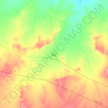
Name: Nekhel topographic map, elevation, terrain.
Location: Nekhel, North Sinai, Egypt (29.75145 33.58599 30.07145 33.90599)
Average elevation: 439 m
Minimum elevation: 348 m
Maximum elevation: 575 m
Make a donation
Gear up for your next adventure:
As an Amazon Associate, this site earns from qualifying purchases at no extra cost to you.
Other topographic maps
Click on a map to view its topography, its elevation and its terrain.
Make a donation
Gear up for your next adventure:
As an Amazon Associate, this site earns from qualifying purchases at no extra cost to you.