
Tanjung Pasir topographic map
Interactive map
Click on the map to display elevation.
About this map
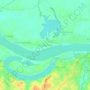
Name: Tanjung Pasir topographic map, elevation, terrain.
Location: Tanjung Pasir, Jambi, Danau Sipin, Jambi, 36111, Indonesia (-1.60631 103.57406 -1.56631 103.61406)
Average elevation: 11 m
Minimum elevation: -1 m
Maximum elevation: 34 m
Other topographic maps
Click on a map to view its topography, its elevation and its terrain.
Taman Anggrek Sri Sudewi
Indonesia > Jambi > Danau Sipin > Jambi > Telanaipura
Average elevation: 21 m