
Lenz topographic map
Interactive map
Click on the map to display elevation.
About this map
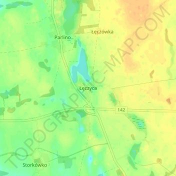
Name: Lenz topographic map, elevation, terrain.
Average elevation: 61 m
Minimum elevation: 45 m
Maximum elevation: 73 m
Other topographic maps
Click on a map to view its topography, its elevation and its terrain.
Alt Damerow
Polen > Woiwodschaft Westpommern > Landkreis Stargard
Alt Damerow, Gemeinde Alt Damerow, Landkreis Stargard, Woiwodschaft Westpommern, 73-112, Polen
Average elevation: 59 m
Jacobshagen
Polen > Woiwodschaft Westpommern > Landkreis Stargard
Jacobshagen, Gemeinde Jacobshagen, Landkreis Stargard, Woiwodschaft Westpommern, 73-130, Polen
Average elevation: 86 m