Geolocate

Walbury Hill topographic map

Interactive map

Click on the map to display elevation.

Walbury Hill

Walbury Hill is a summit of the North Wessex Downs in Berkshire, England. With an elevation of 297 metres (974 ft), it is the highest natural point in South East England. On the hill's summit is the Iron Age hill fort of Walbury Camp, whilst the flanks of the hill lie within the Inkpen and Walbury Hills SSSI. The hill is one of three nationally important chalk wild grasslands in the North Wessex Downs, the others being in the Rushmore and Conholt Downs SSSI and the Hog's Hole SSSI. The summit of the hill is marked by a triangulation pillar, but lies on private land with no public access, although public access is available to the north of the summit via a byway.

Wikipedia (CC-BY-SA 3.0)

About this map

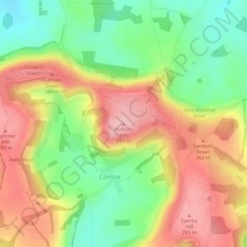
Name: Walbury Hill topographic map, elevation, terrain.

Location: Walbury Hill, West Berkshire, England, RG17 9EH, United Kingdom (51.35241 -1.46510 51.35251 -1.46500)

Average elevation: 222 m

Minimum elevation: 145 m

Maximum elevation: 299 m

West Berkshire trails, hiking, mountain biking, running and outdoor activities

Other topographic maps

Click on a map to view its topography, its elevation and its terrain.

East Garston

United Kingdom > England > West Berkshire

Average elevation: 161 m

Newbury

United Kingdom > England > West Berkshire

Elevations vary from a minimum of 72 m above mean sea level to 122 m at Wash Common. Elevations reach 150–200 m in the directly adjoining hills. The River Kennet and the Kennet and Avon Canal flow east through the centre of the town to reach the Thames at Reading, while the River Lambourn (beside which is…

Average elevation: 97 m

Compton

United Kingdom > England > West Berkshire

Compton is buffered from neighbouring settlements by cultivated fields to all sides. The village is in a gently-sloped dry valley and the fledgling Pang seasonally enters from the north west and discharges in the south east and may be joined at the centre of the village by the Roden from the north, when winter…

Average elevation: 137 m

Brightwalton

United Kingdom > England > West Berkshire

Average elevation: 178 m

West Ilsley

United Kingdom > England > West Berkshire

Average elevation: 161 m

Catmore

United Kingdom > England > West Berkshire

Average elevation: 182 m

East Ilsley

United Kingdom > England > West Berkshire

Average elevation: 148 m

Peasemore

United Kingdom > England > West Berkshire

Average elevation: 155 m

Beedon

United Kingdom > England > West Berkshire

Average elevation: 160 m

Ufton Nervet

United Kingdom > England > West Berkshire

Average elevation: 81 m

Pangbourne

United Kingdom > England > West Berkshire

Average elevation: 64 m

Hungerford

United Kingdom > England > West Berkshire

Average elevation: 131 m

Streatley

United Kingdom > England > West Berkshire

Streatley is a village and civil parish on the River Thames in Berkshire, England. The village faces Goring-on-Thames. The two places share in their shops, services, leisure, sports and much of their transport. Across the river is Goring & Streatley railway station and the village cluster adjoins a lock and…

Average elevation: 95 m

Boxford

United Kingdom > England > West Berkshire

Average elevation: 123 m

Chieveley

United Kingdom > England > West Berkshire

Average elevation: 123 m

Chaddleworth

United Kingdom > England > West Berkshire

Average elevation: 164 m

Inkpen

United Kingdom > England > West Berkshire

Average elevation: 160 m

Hermitage

United Kingdom > England > West Berkshire

Average elevation: 119 m

Padworth

United Kingdom > England > West Berkshire

Average elevation: 77 m

Bradfield

United Kingdom > England > West Berkshire

Average elevation: 77 m

Midgham

United Kingdom > England > West Berkshire

Average elevation: 90 m

Frilsham

United Kingdom > England > West Berkshire > Frilsham

Average elevation: 100 m

Yattendon

United Kingdom > England > West Berkshire

Average elevation: 109 m

Kintbury

United Kingdom > England > West Berkshire

Average elevation: 121 m

Woolhampton

United Kingdom > England > West Berkshire

Average elevation: 85 m

Beech Hill

United Kingdom > England > West Berkshire

Average elevation: 56 m

Brimpton

United Kingdom > England > West Berkshire

Average elevation: 77 m

Sulhamstead

United Kingdom > England > West Berkshire

Average elevation: 69 m

Cold Ash

United Kingdom > England > West Berkshire

Average elevation: 115 m

Englefield

United Kingdom > England > West Berkshire

Average elevation: 57 m

Speen

United Kingdom > England > West Berkshire

Average elevation: 106 m

Enborne

United Kingdom > England > West Berkshire

Average elevation: 104 m

Ashampstead

United Kingdom > England > West Berkshire

Average elevation: 123 m

Welford

United Kingdom > England > West Berkshire

Average elevation: 124 m

Beenham

United Kingdom > England > West Berkshire > Beenham

Average elevation: 77 m

West Woodhay

United Kingdom > England > West Berkshire

Average elevation: 158 m