
Make a donation
Gear up for your next adventure:
As an Amazon Associate, this site earns from qualifying purchases at no extra cost to you.
Nisqually topographic map
Click on the map to display elevation.
Make a donation
Gear up for your next adventure:
As an Amazon Associate, this site earns from qualifying purchases at no extra cost to you.
About this map
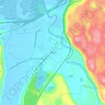
Name: Nisqually topographic map, elevation, terrain.
Location: Nisqually, Thurston County, Washington, United States (47.03649 -122.72124 47.07649 -122.68124)
Average elevation: 34 m
Minimum elevation: -3 m
Maximum elevation: 124 m
Make a donation
Gear up for your next adventure:
As an Amazon Associate, this site earns from qualifying purchases at no extra cost to you.
Other topographic maps
Click on a map to view its topography, its elevation and its terrain.
Olympia
United States > Washington > Thurston County
Olympia is characterized by a diverse topography that ranges from coastal lowlands to the gently sloping Cascade foothills to the southeast. The city is perched at an average elevation of about 150 feet above sea level, lying adjacent to Budd Inlet and surrounded by rich, green hills that rise gradually from…
Average elevation: 49 m
Olympia
United States > Washington > Thurston County
The area is located near the southern limit of the Fraser Glaciation and the underlying sediments consist largely of Vashon-age till and outwash deposited at that time; the area also includes former lakebeds and alluvial deposits associated with proglacial lakes that existed in the area near the end of…
Average elevation: 49 m
Make a donation
Gear up for your next adventure:
As an Amazon Associate, this site earns from qualifying purchases at no extra cost to you.
Centralia Coal Mine Dam No 32B
United States > Washington > Thurston County > Tono
Average elevation: 104 m
Make a donation
Gear up for your next adventure:
As an Amazon Associate, this site earns from qualifying purchases at no extra cost to you.
Make a donation
Gear up for your next adventure:
As an Amazon Associate, this site earns from qualifying purchases at no extra cost to you.
Olympia
United States > Washington > Thurston County
The area is located near the southern limit of the Fraser Glaciation and the underlying sediments consist largely of Vashon-age till and outwash deposited at that time; the area also includes former lakebeds and alluvial deposits associated with proglacial lakes that existed in the area near the end of…
Average elevation: 49 m
Make a donation
Gear up for your next adventure:
As an Amazon Associate, this site earns from qualifying purchases at no extra cost to you.
Olympia
United States > Washington > Thurston County
The area is located near the southern limit of the Fraser Glaciation and the underlying sediments consist largely of Vashon-age till and outwash deposited at that time; the area also includes former lakebeds and alluvial deposits associated with proglacial lakes that existed in the area near the end of…
Average elevation: 49 m
Make a donation
Gear up for your next adventure:
As an Amazon Associate, this site earns from qualifying purchases at no extra cost to you.