
Bashkia Himarë topographic map
Interactive map
Click on the map to display elevation.
About this map
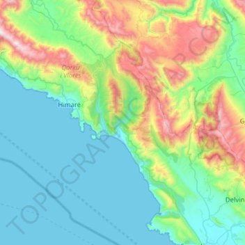
Name: Bashkia Himarë topographic map, elevation, terrain.
Location: Bashkia Himarë, Vlorë County, Southern Albania, Albania (39.87734 19.58027 40.26855 20.02238)
Average elevation: 444 m
Minimum elevation: -1 m
Maximum elevation: 2,005 m
Other topographic maps
Click on a map to view its topography, its elevation and its terrain.
Llogara National Park
Albania > Southern Albania > Vlorë County > Orikum
Phytogeographically, the park falls within the Illyrian deciduous forests terrestrial ecoregion of the Palearctic Mediterranean forests, woodlands, and scrub biome. Its flora is diverse and characterised with high endemism, due to the combination of southern geographic latitude and high altitude variation. The…
Average elevation: 1,024 m