
Kings County topographic map
Interactive map
Click on the map to display elevation.
About this map
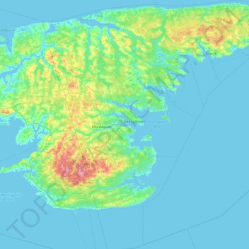
Name: Kings County topographic map, elevation, terrain.
Location: Kings County, Prinz-Edward-Insel, Kanada (45.85881 -62.86540 46.49017 -61.95499)
Average elevation: 16 m
Minimum elevation: -2 m
Maximum elevation: 128 m
Other topographic maps
Click on a map to view its topography, its elevation and its terrain.
Cornwall
Cornwall, Queens County, Prinz-Edward-Insel, C0A 1H0, Kanada
Average elevation: 18 m
Borden
Kanada > Prinz-Edward-Insel > Borden-Carleton
Borden, Borden-Carleton, Prince County, Prinz-Edward-Insel, C0B 1X0, Kanada
Average elevation: 3 m
Southampton
Kanada > Prinz-Edward-Insel > St. Peters
Southampton, St. Peters, Lot 41, Kings County, Prinz-Edward-Insel, C0A 2A0, Kanada
Average elevation: 36 m