
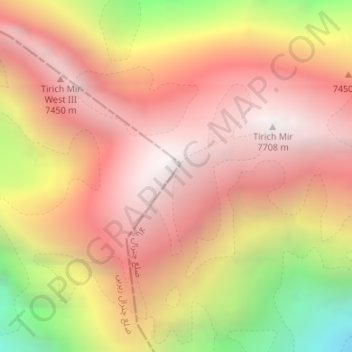
Tirich Mir topographic map
Interactive map
Click on the map to display elevation.
About this map
Name: Tirich Mir topographic map, elevation, terrain.
Average elevation: 6,802 m
Minimum elevation: 5,610 m
Maximum elevation: 7,666 m
Tirich Mir (also spelled Terich Mir, Terichmir and Turch Mir) is the highest mountain of the Hindu Kush range, and the highest mountain in the world outside of the Himalayas–Karakoram range. It is located in the Chitral District of Khyber Pakhtunkhwa, Pakistan. The first recorded ascent of the mountain was on 21 July 1950 by a Norwegian expedition consisting of Arne Næss, P. Kvernberg, H. Berg, and Tony Streather. Tirich Mir overlooks the town of Chitral, and can be easily seen from the main bazaar. It is the closest mountain to Aconcagua which is higher than Aconcagua, and thus determines Aconcagua's topographic isolation.
Other topographic maps
Click on a map to view its topography, its elevation and its terrain.
Zondrangram
Pakistan > Khyber Pakhtunkhwa > Former Chitrāl District
Zondrangram, Upper Chitral District, Former Chitrāl District, Malakand Division, Khyber Pakhtunkhwa, Pakistan
Average elevation: 3,111 m
Mastuj
Pakistan > Khyber Pakhtunkhwa > Former Chitrāl District
Mastuj, Upper Chitral District, Former Chitrāl District, Malakand Division, Khyber Pakhtunkhwa, Pakistan
Average elevation: 3,059 m
Water Flow
Pakistan > Khyber Pakhtunkhwa > Former Chitrāl District > Parsan
Water Flow, Parsan, Lower Chitral District, Former Chitrāl District, Malakand Division, Khyber Pakhtunkhwa, Pakistan
Average elevation: 2,972 m