
Zondrangram topographic map
Interactive map
Click on the map to display elevation.
About this map
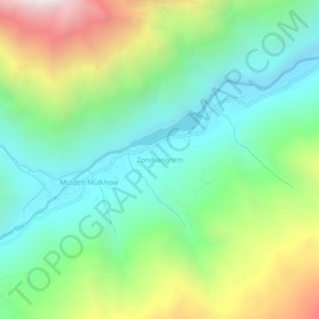
Name: Zondrangram topographic map, elevation, terrain.
Average elevation: 3,111 m
Minimum elevation: 2,548 m
Maximum elevation: 4,257 m
Other topographic maps
Click on a map to view its topography, its elevation and its terrain.
Mastuj
Pakistan > Khyber Pakhtunkhwa > Former Chitrāl District
Mastuj, Upper Chitral District, Former Chitrāl District, Malakand Division, Khyber Pakhtunkhwa, Pakistan
Average elevation: 3,059 m
Water Flow
Pakistan > Khyber Pakhtunkhwa > Former Chitrāl District > Parsan
Water Flow, Parsan, Lower Chitral District, Former Chitrāl District, Malakand Division, Khyber Pakhtunkhwa, Pakistan
Average elevation: 2,972 m