
Make a donation
Gear up for your next adventure:
As an Amazon Associate, this site earns from qualifying purchases at no extra cost to you.
Hartford topographic map
Click on the map to display elevation.
Make a donation
Gear up for your next adventure:
As an Amazon Associate, this site earns from qualifying purchases at no extra cost to you.
Hartford
Several elements of the Downtown Hartford Historic District, including the courthouse, jail and main block of the Hartford City Hall, remain virtually intact on the exterior. As in most downtowns, however, storefronts have suffered the greatest changes. Fortunately, most of the upper elevations of these buildings have been well preserved so that the district's streetscape retains its historic character. Despite alterations, the district remains a visually distinct entity due to the extensively renovated older buildings and new construction that define its edges.
Make a donation
Gear up for your next adventure:
As an Amazon Associate, this site earns from qualifying purchases at no extra cost to you.
About this map
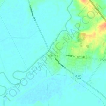
Name: Hartford topographic map, elevation, terrain.
Location: Hartford, Ohio County, Kentucky, United States (37.43446 -86.91460 37.46950 -86.87671)
Average elevation: 123 m
Minimum elevation: 115 m
Maximum elevation: 155 m
Make a donation
Gear up for your next adventure:
As an Amazon Associate, this site earns from qualifying purchases at no extra cost to you.
Other topographic maps
Click on a map to view its topography, its elevation and its terrain.