
Eysturoy topographic map
Interactive map
Click on the map to display elevation.
About this map
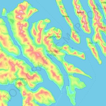
Name: Eysturoy topographic map, elevation, terrain.
Location: Eysturoy, Eysturoy region, Faroe Islands (62.05596 -7.11699 62.34175 -6.58892)
Average elevation: 162 m
Minimum elevation: -8 m
Maximum elevation: 879 m
Other topographic maps
Click on a map to view its topography, its elevation and its terrain.
Faroe Islands
Faroe Islands > Eysturoy region
The climate varies greatly over small distances, due to the altitude, ocean currents, topography and winds. Precipitation varies considerably throughout the archipelago. In some highland areas, snow cover can last for months with snowfalls possible for the greater part of the year (on the highest peaks, summer…
Average elevation: 26 m